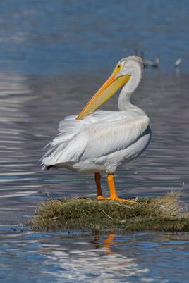
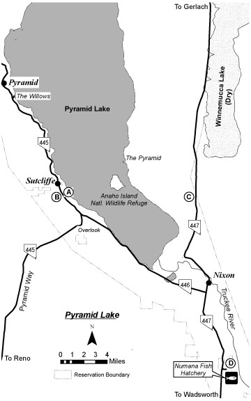
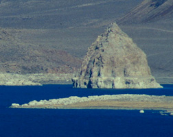
 American White Pelican - Photo by Jeff Bleam American White Pelican - Photo by Jeff Bleam WHAT TO EXPECT Pyramid Lake, a 125,000-acre desert lake, lies at the terminus of the Truckee River approximately 30 miles northeast of Reno. The lake, a remnant of Pleistocene Lake Lahontan, contains a number of tufa formations and the Anaho Island National Wildlife Refuge, one of the largest nesting colonies of the American White Pelican in the United States. The island and surrounding waters are closed to the public, although other areas of the lake are open. A spotting scope is recommended. Pyramid Lake is situated within a Paiute Indian Reservation, and visitors must purchase a day use permit, available at the Sutcliffe Ranger Station or on the Pyramid Lake web site. The web site has up-to-date information on permit locations, hours of operation and pricing. You can also call the Pyramid Lake Paiute Tribe in Nixon (775-574-1000) Pyramid Lake is a Nevada Important Bird Area. Best time of year: Waterfowl are present throughout the year. Pelicans nest in spring and summer. Riparian areas along the Truckee River and the Willows can be productive in the spring and fall. Shore birding can be excellent in the fall in low water years at the south end of the lake from the highway to the Truckee River delta. Notable species: The lake surface is good for American White Pelican in breeding season and diverse waterfowl in winter, with four species of loons and six species of grebes possible. Coastal strays such as scoters and jaegers can be found in the fall. In the summer, Black-throated Sagebrush and Brewer’s Sparrows can be found in the surrounding sagebrush habitat. This area has produced a number of rarities; check the Nevada Birds List Server (see Introduction). Pyramid Lake eBird Link Precautions: The Paiute Reservation Council prefers that you stay on established routes. Note: The east side of the lake as well as The Needles at the north end are off limits to the public. HOW TO GET THERE Pyramid Lake can be reached in two ways: Via Pyramid Way: From the I-80 & US 395 interchange, drive east on I-80 approximately 2 miles to Exit 18 Pyramid Way. Turn left (north) on Pyramid Way/SR 445. Drive about 9 miles through residential areas in Sparks with multiple stoplights and frequently heavy traffic. Continue another 30 miles to the junction of SR 445 and SR 446. Just before the junction, a pullout on the right offers a panoramic view of the lake, Anaho Island, and the smaller namesake, The Pyramid. Continue approximately 3 miles on SR 445 to Sutcliffe. Permits are available at the ranger station (intermittent hours) in the marina area at the northern end of Sutcliffe. Via Wadsworth: Take I-80 east about 30 miles from the Vista Exit at the east end of Reno to Exit 43 Wadsworth. Go left (north). Continue north to Wadsworth and turn left onto SR 447 (about 1.4 miles from I-80). Obey the speed limits closely. Continue north 16 miles to the junction of SR 447 & SR 446 and the Nixon Store. Turn left and continue to the areas described below. Google Maps Link: https://goo.gl/maps/WrEbaUoaVEKmXTuy7 Pyramid Lake eBird Map Link Note: All descriptions of birding routes are based upon Sutcliffe as the starting point (about 16 miles northwest of the Nixon Store). POPULAR BIRDING ROUTE: Pyramid Lake Fisheries (PLF) Hatchery: from the junction of 447 and 446 at the southern edge of Sutcliffe turn right (east) on Sutcliffe Drive and go 0.1 mile to a fork where Sutcliffe Drive curves left and a gravel road splits off to the right. Follow the gravel road and bare right where it forks. When you come to the corner of the fisheries’ fence, park along the side of the road and climb the embankment on the left to view the fisheries pond, which can be good for various waterfowl. Return to your car and continue along this road to where it curves to the left. Find a place to park on the left and walk along the fence down to the lake. This area can be very productive for waterfowl and gulls in the fall and winter. Backtrack to fork in the gravel road and drive down to the lake. Turn right and park along the lake shore near the entrance to the fishery. Scope the shore for waterfowl and gulls. If time permits, a walk along the perimeter of the fishery to check the Russian Olives can be productive for land birds. Backtrack to SR 445. The Sutcliffe Marina area provides a good vantage point for scoping the lake. From SR 445 turn right (north). Turn right on Sutcliffe Drive to access this area. SR 445 becomes a gravel road in 8.3 miles. Enroute stops at Separator Beach, Pelican Point, Windless Bay and Warrior Point can be productive. After the road becomes gravel, drive an additional 2.3 miles until reaching a privately owned ranch on the left and a parking pullout under cottonwood trees on the right. This area is called Big Canyon. Park and explore for migrants and occasional vagrants. Do not trespass on private property on the west side of the road. The Willows: The large grove of mature black willows near the lake, called The Willows, can be very productive for migrating songbirds. To access the Willows backtrack about 0.3 mile to a blocked dirt road on the left that leads down to the lakeshore (about another 0.4 mile). Park here and bird down to the Willows and the lake shore. Willows eBird Link https://ebird.org/hotspot/L269368?yr=all&m=&rank=mrec Along SR446 to the Lakeshore: Backtrack on SR 445 to the intersection with SR 446. Bear left on SR 446 toward Nixon. Check close-to-shore areas for waterbirds and gulls at enroute stops at Tamaracks, Indian Head, Wino Beach, Sandhole, Rawhide, Blockhouse and Cattleguard beaches. Watch for the Popcorn Rock sign at 7.9 miles south of the intersection. About 1 mile farther south, approaching the delta of the Truckee River, a single cottonwood tree marks the location of a left turn onto a gravel road leading down to the lake shore identified by a Trail Access: Tahoe-Pyramid Bikeway sign. Scope the lake for grebes, pelicans, cormorants, waterfowl, gulls, and terns. If time permits, a walk east and north along the shore to the mouth of the Truckee River can be excellent in the fall for shore birds. The mouth of the river is usually teeming with pelicans, cormorants, gulls, waterfowl and shorebirds. Return to SR 446 and continue south 4.1 miles to the SR 446 & SR 447 intersection and the Nixon Store (gas). The Pyramid Lake Museum and Visitor Center (775-547-1088) on the left side of SR 446 is well worth a visit Numana Wetlands: Take SR 447 right (south) for 7 miles to the Numana Wetlands. If you are returning to Reno or coming from Reno via Wadsworth, this area is well worth a visit, especially in the spring and fall. Turn left at the Numana Fish Hatchery sign (a right turn coming from Wadsworth). Follow the paved road 0.7 mile down the hill to the hatchery entrance, where the pavement ends. Continue straight on the gravel road another 0.2 mile down to a dirt road along the river, following the Wetland Trail signs. Turn right, go 0.1 mile, and park in the grass parking lot at the entrance to the Numana Wetlands Trail/Tahoe-Pyramid Bikeway, an access point for riparian birding along the Truckee River. Return to SR 447, turn left (south), and follow SR 447 to the I-80 & Wadsworth interchange, as described in the birding route. |


