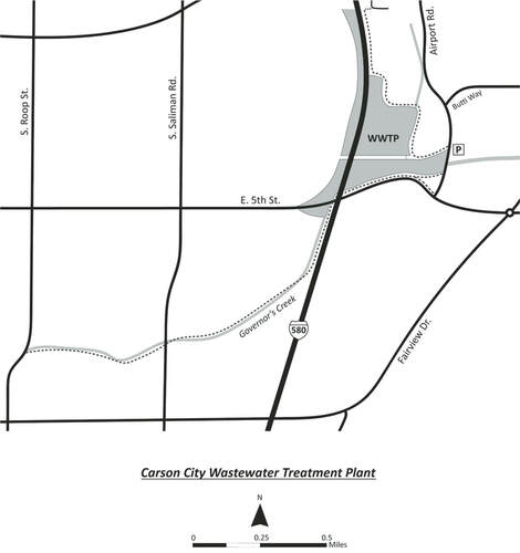
Google Map of the Area
POPULAR BIRDING ROUTES: The best birding is from the path that begins on the northern edge of the pond adjacent to Airport Rd. Scan the reeds to your left for Sora, Virginia Rail, Marsh Wren and Song Sparrow. Northern Harriers are often flying low over this patch. Check the dry areas among the reeds for Wilson’s Snipe. At the first corner you will turn right. Proceed down the path and bird the large open ponds and mudflats to your left for waterfowl, shorebirds, and gulls. Check the fences for Say’s Phoebe, Mountain Bluebird, and, in Spring, Barn, Violet-green, Tree, Northern Rough-wing, and Cave Swallows, which will also be swarming the skies above. At the next corner you will turn left. Check the canal to the north for Ring-necked Duck and Cinnamon Teal. If the water to the south is shallow (water levels change here frequently), look for peeps there. The grassland to the north may have Savannah Sparrow and Meadowlark. At the next corner, bird the open pond adjacent to the freeway for diving ducks and check the surrounding trees for Great-tailed Grackle. Turn around here and proceed back the way you came. There is also a paved path that skirts the southern edge of the ponds, goes under the freeway, and then follows Governor’s Creek all the way to S. Roop St. This route is less productive but can be good for sparrows and wrens along the creek and raptors in the agricultural fields. The path is approximately two miles from Airport Rd. to S. Roop St. |

