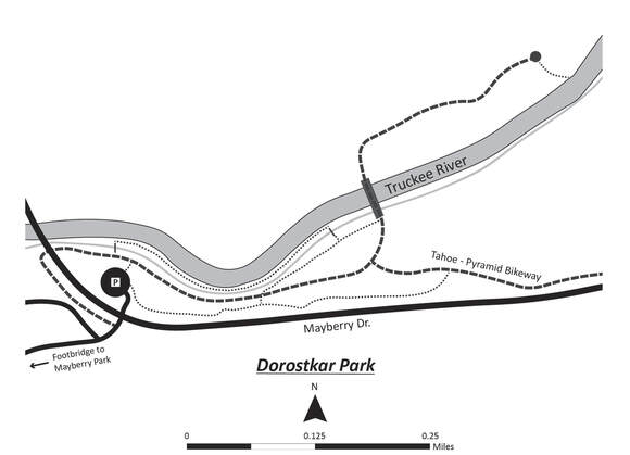
 WHAT TO EXPECT: Dorostkar Park, in suburban west Reno, is a great place to spend a few hours checking out the bird life near the Truckee River. The park has five picnic tables adjacent to the parking lot entrance, and few inviting benches along paths. The park’s paved and dirt paths have gentle grades that meander through riparian habitat, which consists of Fremont Cottonwood, Red Willow, and Russian Olive trees, with an understory of Wood’s Rose, Coyote Willow, and alder. A mixed sagebrush and rabbitbrush habitat occurs in drier areas away from the river. There is also a nature trail with interpretive signs. BEST TIME OF YEAR: Year-round NOTABLE SPECIES: In winter, Common Goldeneye, Bufflehead, Hooded Mergansers and American Dippers may be seen in the river, along with Common Mergansers (year-round). Belted Kingfishers make forays up and down above the river. Hermit Thrush are regular winter visitors.In spring and summer, swallows put on a show: Tree, Barn, Cliff, and Northern Rough-winged Swallows are often seen. In summer, Bewick’s and House Wrens, Black-headed Grosbeak, Barn Swallow, and Northern Flicker nest in the park. Notable raptors include Bald Eagle and Red-shouldered Hawk; Osprey fish over the river summer through fall. Check for Anna’s and Calliope hummingbirds. Black Phoebe hunt from branches over the river. Steller’s Jay, California Scrub-Jay, Black-billed Magpie, Spotted Towhee, and California Quail are present year-round. HOW TO GET THERE: Dorostkar Google Map of the Area From the I-80 & I-580/US 395 interchange in Reno head west on I-80 about 4 miles to Exit 10, McCarran Blvd. Turn left (south) onto South McCarran Blvd. and follow until the intersection with Mayberry Drive, turn right (west) onto Mayberry Drive, travel about 1.3 miles and bur right (north) into the parking lot for the park (there is a sign). POPULAR BIRDING ROUTES: Dorostkar Park Trail Map Cross the paved bike trail at the end of the parking lot and go slightly left to cross the small footbridge over the irrigation ditch and turn right onto the narrow dirt path that runs between the river and the ditch. There are several short trails down from this path to access the river. Bird the riparian habitat along either side of this path until it ends at another wooden footbridge, which will take you back over the irrigation ditch. Barn Swallows nest under this footbridge and can be seen collecting mud from banks of the ditch to make their nests. Leaving the footbridge, turn left onto the gravel trail to intersect the paved bike path, which is part of the Tahoe to Pyramid Bikeway, at a foot/bike-traffic bridge over the Truckee River. You can continue east on the paved trail on the north side of the river for a short distance to its terminus at a picnic table. There are a couple of spots here to get down to the river’s edge. Crossing back over the river bridge, you can take the gravel path or the paved bike path back, or the Nature trail to the parking area. Optional Side Trip: Mayberry Park is about a half-mile away. To access Mayberry Park, turn left onto the paved bike path, which will take you under the Mayberry Bridge and connect with Aspen Glen Drive. This is a quiet side street bordered by trees and open fields, and the birding is good. Watch for the occasional car or bike and respect the private property on either side of the street. Aspen Glen Drive dead-ends at a foot/bike-traffic bridge over the Truckee River, which provides great views of the river in both directions. Mink may be seen hunting along the banks of the river to the right. A short distance after crossing the river, turn left onto Mayberry Park’s paved walking/biking path, which parallels the Truckee River for about 0.7 mile upstream. |
