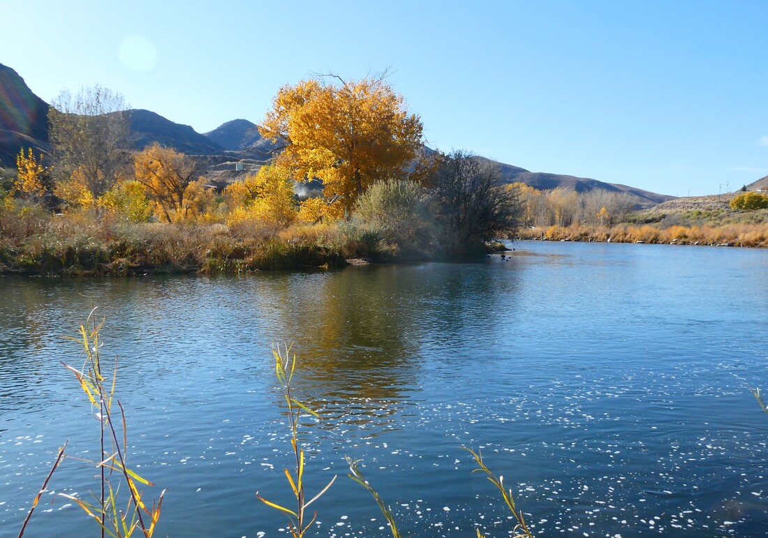
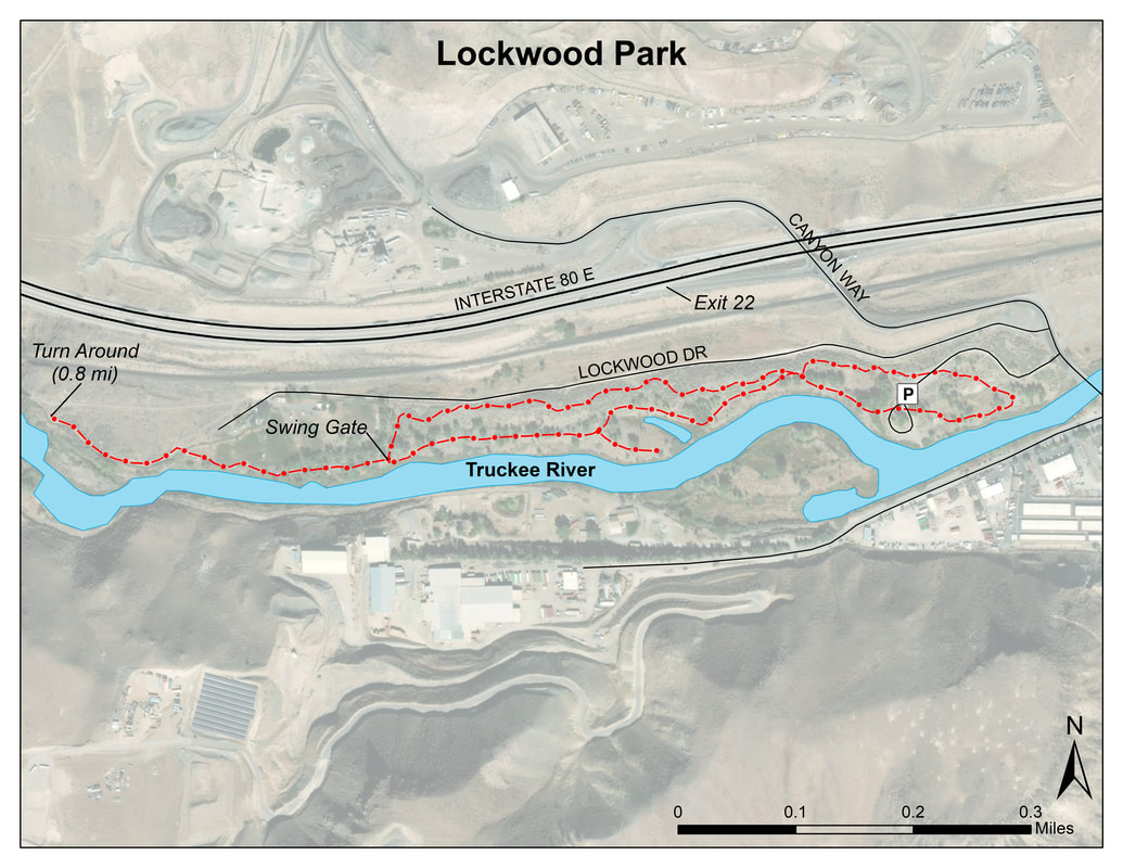
WHAT TO EXPECT: Located along the Truckee River this park has off-street parking and paved walking/bike paths with gentle grades that parallel the Truckee River. Along the way, there are picnic tables (with barbecue grills) and a grassy area adjacent to the path. The riparian habitat consists of mature cottonwoods, willow trees and Russian Olive trees. It is a good place to spend a few hours or a half-day or more birding close to Reno’s western suburbs.
Best time of year: March through October for migrants and nesting birds, but winter offers excellent opportunities to see a variety of diving ducks in the river. Notable species: Mayberry Park eBird Hotspot In winter, Common and Barrow’s Goldeneye, Hooded Merganser, Bufflehead, and American Dippers frequent the river, as well as Common Merganser year-round. Mountain Bluebird, Townsend’s Solitaire, and Hermit Thrush are possible in winter. Notable raptors include Bald and Golden Eagles, Osprey (summer through fall), Cooper’s and Red-shouldered Hawks. Red-tailed Hawks and Great Horned Owls have nested in the park over several years. Tree, Barn, Cliff and Rough-winged Swallows nest in the park. Yellow Warbler, Warbling Vireo, Western Kingbird, Western Wood-Pewee, House and Bewicks Wrens, Black-headed Grosbeak, and Bullocks Oriole are common. Hooded Oriole may also be present. Look for Black-chinned, Anna’s and Calliope hummingbirds and Band-tailed Pigeons in summer. Several species of woodpeckers, including Red-breasted and Red-naped Sapsuckers and Lewis’s Woodpeckers are possible. Many species of finches and sparrows frequent the park in summer and winter, check for vagrants among the flocks of sparrows, especially in winter. Precautions: The park may be crowded on spring and summer weekends with families picnicking. HOW TO GET THERE: Google Map of the Area From the I-80 & I-580/US 395 interchange in Reno head west on I-80 about four miles to Exit 10, McCarran Blvd. Turn left (south) onto South McCarran Blvd. and follow until the intersection with Fourth Street. Turn right (west) on Fourth Street. Follow the road until you get to Woodland Avenue, approximately two miles. Turn left; Woodland Avenue will dead-end at Mayberry Park. There is off-street parking at the park, and paved walking paths. POPULAR BIRDING ROUTES: Mayberry Park Trail Map From the parking lot the paved path heads east and west along the river. There are large, mature trees along the riparian corridor that offer habitat to nesting birds including most cavity nesters, and often raptors such as Great-horned Owls and Red-tailed Hawks. A paved foot/bike path parallels the Truckee River in both directions from the parking area (total length about 0.7 (round trip 1.4 miles out and back). Several small dirt trails lead through the riparian habitat from the paved path to the river. To the east, the paved trail ends near a foot-and-bike-traffic bridge over the river that accesses Aspen Glen Drive (Dorostkar Park may be reached by walking along this street for about one-half mile and crossing under or over Mayberry Drive). Walking west along the paved path at Mayberry Park leads to another foot/bike path near the Patagonia Outlet parking area. For an optional side trip, cross the river on this western bridge, go a short distance up the hill and turn left onto a dirt path that parallels the Last Chance irrigation ditch. The trail is about 0.5 mile. There is good birding on either side of the trail and good views down to the river and riparian habitat below. The trail dead-ends at private property, so you must return the way you came (out and back, this will total about a mile). Optional Side Trip: For those who enjoy a bit of uphill walking, another side trip would be to take the Tom Cooke Trail, which is the steep dirt trail that switch-backs up the slope near the intersection with the irrigation ditch path you just left. The Tom Cooke trails goes about 0.6 miles up to intersect the Steamboat Ditch trail, which is a whole other trip entirely! 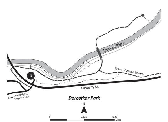 WHAT TO EXPECT: Dorostkar Park, in suburban west Reno, is a great place to spend a few hours checking out the bird life near the Truckee River. The park has five picnic tables adjacent to the parking lot entrance, and few inviting benches along paths. The park’s paved and dirt paths have gentle grades that meander through riparian habitat, which consists of Fremont Cottonwood, Red Willow, and Russian Olive trees, with an understory of Wood’s Rose, Coyote Willow, and alder. A mixed sagebrush and rabbitbrush habitat occurs in drier areas away from the river. There is also a nature trail with interpretive signs.
BEST TIME OF YEAR: Year-round NOTABLE SPECIES: In winter, Common Goldeneye, Bufflehead, Hooded Mergansers and American Dippers may be seen in the river, along with Common Mergansers (year-round). Belted Kingfishers make forays up and down above the river. Hermit Thrush are regular winter visitors.In spring and summer, swallows put on a show: Tree, Barn, Cliff, and Northern Rough-winged Swallows are often seen. In summer, Bewick’s and House Wrens, Black-headed Grosbeak, Barn Swallow, and Northern Flicker nest in the park. Notable raptors include Bald Eagle and Red-shouldered Hawk; Osprey fish over the river summer through fall. Check for Anna’s and Calliope hummingbirds. Black Phoebe hunt from branches over the river. Steller’s Jay, California Scrub-Jay, Black-billed Magpie, Spotted Towhee, and California Quail are present year-round. HOW TO GET THERE: Dorostkar Google Map of the Area From the I-80 & I-580/US 395 interchange in Reno head west on I-80 about 4 miles to Exit 10, McCarran Blvd. Turn left (south) onto South McCarran Blvd. and follow until the intersection with Mayberry Drive, turn right (west) onto Mayberry Drive, travel about 1.3 miles and bur right (north) into the parking lot for the park (there is a sign). POPULAR BIRDING ROUTES: Dorostkar Park Trail Map Cross the paved bike trail at the end of the parking lot and go slightly left to cross the small footbridge over the irrigation ditch and turn right onto the narrow dirt path that runs between the river and the ditch. There are several short trails down from this path to access the river. Bird the riparian habitat along either side of this path until it ends at another wooden footbridge, which will take you back over the irrigation ditch. Barn Swallows nest under this footbridge and can be seen collecting mud from banks of the ditch to make their nests. Leaving the footbridge, turn left onto the gravel trail to intersect the paved bike path, which is part of the Tahoe to Pyramid Bikeway, at a foot/bike-traffic bridge over the Truckee River. You can continue east on the paved trail on the north side of the river for a short distance to its terminus at a picnic table. There are a couple of spots here to get down to the river’s edge. Crossing back over the river bridge, you can take the gravel path or the paved bike path back, or the Nature trail to the parking area. Optional Side Trip: Mayberry Park is about a half-mile away. To access Mayberry Park, turn left onto the paved bike path, which will take you under the Mayberry Bridge and connect with Aspen Glen Drive. This is a quiet side street bordered by trees and open fields, and the birding is good. Watch for the occasional car or bike and respect the private property on either side of the street. Aspen Glen Drive dead-ends at a foot/bike-traffic bridge over the Truckee River, which provides great views of the river in both directions. Mink may be seen hunting along the banks of the river to the right. A short distance after crossing the river, turn left onto Mayberry Park’s paved walking/biking path, which parallels the Truckee River for about 0.7 mile upstream.
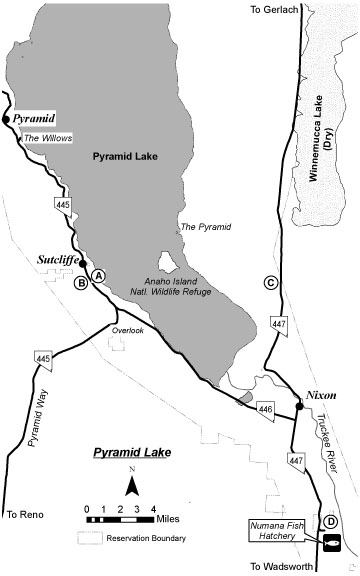 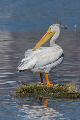 American White Pelican - Photo by Jeff Bleam American White Pelican - Photo by Jeff Bleam WHAT TO EXPECT Pyramid Lake, a 125,000-acre desert lake, lies at the terminus of the Truckee River approximately 30 miles northeast of Reno. The lake, a remnant of Pleistocene Lake Lahontan, contains a number of tufa formations and the Anaho Island National Wildlife Refuge, one of the largest nesting colonies of the American White Pelican in the United States. The island and surrounding waters are closed to the public, although other areas of the lake are open. A spotting scope is recommended. Pyramid Lake is situated within a Paiute Indian Reservation, and visitors must purchase a day use permit, available at the Sutcliffe Ranger Station or on the Pyramid Lake web site. The web site has up-to-date information on permit locations, hours of operation and pricing. You can also call the Pyramid Lake Paiute Tribe in Nixon (775-574-1000) Pyramid Lake is a Nevada Important Bird Area. Best time of year: Waterfowl are present throughout the year. Pelicans nest in spring and summer. Riparian areas along the Truckee River and the Willows can be productive in the spring and fall. Shore birding can be excellent in the fall in low water years at the south end of the lake from the highway to the Truckee River delta. Notable species: The lake surface is good for American White Pelican in breeding season and diverse waterfowl in winter, with four species of loons and six species of grebes possible. Coastal strays such as scoters and jaegers can be found in the fall. In the summer, Black-throated Sagebrush and Brewer’s Sparrows can be found in the surrounding sagebrush habitat. This area has produced a number of rarities; check the Nevada Birds List Server (see Introduction). Pyramid Lake eBird Link Precautions: The Paiute Reservation Council prefers that you stay on established routes. Note: The east side of the lake as well as The Needles at the north end are off limits to the public. HOW TO GET THERE Pyramid Lake can be reached in two ways: Via Pyramid Way: From the I-80 & US 395 interchange, drive east on I-80 approximately 2 miles to Exit 18 Pyramid Way. Turn left (north) on Pyramid Way/SR 445. Drive about 9 miles through residential areas in Sparks with multiple stoplights and frequently heavy traffic. Continue another 30 miles to the junction of SR 445 and SR 446. Just before the junction, a pullout on the right offers a panoramic view of the lake, Anaho Island, and the smaller namesake, The Pyramid. Continue approximately 3 miles on SR 445 to Sutcliffe. Permits are available at the ranger station (intermittent hours) in the marina area at the northern end of Sutcliffe. Via Wadsworth: Take I-80 east about 30 miles from the Vista Exit at the east end of Reno to Exit 43 Wadsworth. Go left (north). Continue north to Wadsworth and turn left onto SR 447 (about 1.4 miles from I-80). Obey the speed limits closely. Continue north 16 miles to the junction of SR 447 & SR 446 and the Nixon Store. Turn left and continue to the areas described below. Google Maps Link: https://goo.gl/maps/WrEbaUoaVEKmXTuy7 Pyramid Lake eBird Map Link Note: All descriptions of birding routes are based upon Sutcliffe as the starting point (about 16 miles northwest of the Nixon Store). POPULAR BIRDING ROUTE: Pyramid Lake Fisheries (PLF) Hatchery: from the junction of 447 and 446 at the southern edge of Sutcliffe turn right (east) on Sutcliffe Drive and go 0.1 mile to a fork where Sutcliffe Drive curves left and a gravel road splits off to the right. Follow the gravel road and bare right where it forks. When you come to the corner of the fisheries’ fence, park along the side of the road and climb the embankment on the left to view the fisheries pond, which can be good for various waterfowl. Return to your car and continue along this road to where it curves to the left. Find a place to park on the left and walk along the fence down to the lake. This area can be very productive for waterfowl and gulls in the fall and winter. Backtrack to fork in the gravel road and drive down to the lake. Turn right and park along the lake shore near the entrance to the fishery. Scope the shore for waterfowl and gulls. If time permits, a walk along the perimeter of the fishery to check the Russian Olives can be productive for land birds. Backtrack to SR 445. The Sutcliffe Marina area provides a good vantage point for scoping the lake. From SR 445 turn right (north). Turn right on Sutcliffe Drive to access this area. SR 445 becomes a gravel road in 8.3 miles. Enroute stops at Separator Beach, Pelican Point, Windless Bay and Warrior Point can be productive. After the road becomes gravel, drive an additional 2.3 miles until reaching a privately owned ranch on the left and a parking pullout under cottonwood trees on the right. This area is called Big Canyon. Park and explore for migrants and occasional vagrants. Do not trespass on private property on the west side of the road. The Willows: The large grove of mature black willows near the lake, called The Willows, can be very productive for migrating songbirds. To access the Willows backtrack about 0.3 mile to a blocked dirt road on the left that leads down to the lakeshore (about another 0.4 mile). Park here and bird down to the Willows and the lake shore. Willows eBird Link https://ebird.org/hotspot/L269368?yr=all&m=&rank=mrec Along SR446 to the Lakeshore: Backtrack on SR 445 to the intersection with SR 446. Bear left on SR 446 toward Nixon. Check close-to-shore areas for waterbirds and gulls at enroute stops at Tamaracks, Indian Head, Wino Beach, Sandhole, Rawhide, Blockhouse and Cattleguard beaches. Watch for the Popcorn Rock sign at 7.9 miles south of the intersection. About 1 mile farther south, approaching the delta of the Truckee River, a single cottonwood tree marks the location of a left turn onto a gravel road leading down to the lake shore identified by a Trail Access: Tahoe-Pyramid Bikeway sign. Scope the lake for grebes, pelicans, cormorants, waterfowl, gulls, and terns. If time permits, a walk east and north along the shore to the mouth of the Truckee River can be excellent in the fall for shore birds. The mouth of the river is usually teeming with pelicans, cormorants, gulls, waterfowl and shorebirds. Return to SR 446 and continue south 4.1 miles to the SR 446 & SR 447 intersection and the Nixon Store (gas). The Pyramid Lake Museum and Visitor Center (775-547-1088) on the left side of SR 446 is well worth a visit Numana Wetlands: Take SR 447 right (south) for 7 miles to the Numana Wetlands. If you are returning to Reno or coming from Reno via Wadsworth, this area is well worth a visit, especially in the spring and fall. Turn left at the Numana Fish Hatchery sign (a right turn coming from Wadsworth). Follow the paved road 0.7 mile down the hill to the hatchery entrance, where the pavement ends. Continue straight on the gravel road another 0.2 mile down to a dirt road along the river, following the Wetland Trail signs. Turn right, go 0.1 mile, and park in the grass parking lot at the entrance to the Numana Wetlands Trail/Tahoe-Pyramid Bikeway, an access point for riparian birding along the Truckee River. Return to SR 447, turn left (south), and follow SR 447 to the I-80 & Wadsworth interchange, as described in the birding route. 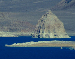 Pyramid Lake - Photo by Alan Gubanich
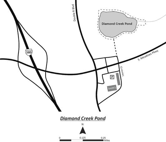
Google Map of the Area
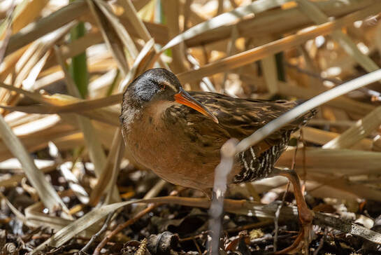
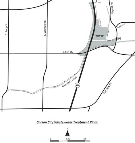
POPULAR BIRDING ROUTES: The best birding is from the path that begins on the northern edge of the pond adjacent to Airport Rd. Scan the reeds to your left for Sora, Virginia Rail, Marsh Wren and Song Sparrow. Northern Harriers are often flying low over this patch. Check the dry areas among the reeds for Wilson’s Snipe. At the first corner you will turn right. Proceed down the path and bird the large open ponds and mudflats to your left for waterfowl, shorebirds, and gulls. Check the fences for Say’s Phoebe, Mountain Bluebird, and, in Spring, Barn, Violet-green, Tree, Northern Rough-wing, and Cave Swallows, which will also be swarming the skies above. At the next corner you will turn left. Check the canal to the north for Ring-necked Duck and Cinnamon Teal. If the water to the south is shallow (water levels change here frequently), look for peeps there. The grassland to the north may have Savannah Sparrow and Meadowlark. At the next corner, bird the open pond adjacent to the freeway for diving ducks and check the surrounding trees for Great-tailed Grackle. Turn around here and proceed back the way you came. There is also a paved path that skirts the southern edge of the ponds, goes under the freeway, and then follows Governor’s Creek all the way to S. Roop St. This route is less productive but can be good for sparrows and wrens along the creek and raptors in the agricultural fields. The path is approximately two miles from Airport Rd. to S. Roop St.
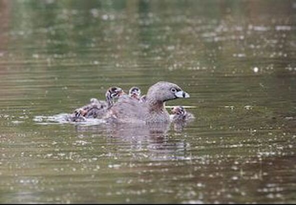
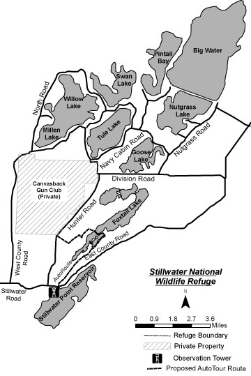 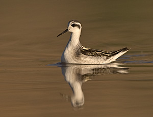 Red-necked Phalarope - Photo by Steve Ting Red-necked Phalarope - Photo by Steve Ting WHAT TO EXPECT: Stillwater National Wildlife Refuge (NWR), located 73 miles east of Reno, usually requires at least a full day trip. The refuge is located on the edge of the Carson Sink, which is the terminus of the Carson River and consists of numerous wetland units that are managed to maintain natural biological diversity. The 80,000-acre refuge is a designated Western Hemisphere Shorebird Reserve and a significant stopover for migrants along the Pacific Flyway. Stop at the Stillwater NWR Headquarters before entering the refuge (details below). Stillwater NWR is part of the Lahontan Valley Wetlands Nevada Important Bird Area. BEST TIME OF YEAR: All year is productive, with tens of thousands of shorebirds from late April to mid-May and, again, July through September. Waterfowl, sometimes in the hundreds of thousands, arrive in late fall. NOTABLE SPECIES: Shorebirds and wading birds are abundant spring through fall, including good numbers of American White Pelican, White-faced Ibis, and Wilson's and Red-necked Phalaropes. Snowy Plover nests here. Tundra Swans gather in early winter. The refuge is Nevada's largest Bald Eagle winter residence. Approximately half the Canvasback population in the Pacific Flyway winter here. Wintering raptors include Golden Eagle, Rough-legged Hawk, and Prairie Falcon. Over 220 species have been recorded here. This area has produced a number of rarities; check the Nevada Birds List Server and eBird below. eBird Hotspot Link PRECAUTIONS: Exercise caution driving along the refuge roads during wet weather to avoid becoming mired in muddy dirt roads or shoulders. Plan for sufficient drinking water as well as protection from the elements, especially during warmer months. HOW TO GET THERE: From the I-80 & US 395 interchange, drive east on I-80 for approximately 32 miles to Exit 48, the second Fernley exit; bear right and over the railroad overpass. Enter the roundabout and exit east onto US 50. Continue 26 miles to Fallon. (Side Trip A) Proceed 12.3 miles on Stillwater Road/SR 116, which turns into East County Road. Stop at the Stillwater NWR Headquarters (U.S. Fish and Wildlife Service) - 1020 New River Parkway, #305, Fallon 89407 (775-423-5128). Just east of Fallon, NV, turn south on Harrigan Road and go a little over one half mile, then turn east on New River Parkway and take the first right. The refuge office is on the east end of the building. To get to the actual refuge, go about four and a half miles east of Fallon, NV on Highway 50, then head east on State Route 116, otherwise known as Stillwater Road. Stay on Stillwater Road for another twelve miles. You’ve reached the refuge when the pavement ends, but you’ll need to keep going to find the marsh! Google Map of the Area POPULAR BIRDING ROUTE: Just beyond the refuge maintenance shop area on the right, park at Stillwater Point Reservoir (restrooms). A short path leads to a large interpretive viewing platform overlooking open water and wetlands. A new, one-way interpretive Auto Tour Route, planned for early 2008, begins at Stillwater Point Reservoir. It travels the perimeter of Duff's Pond, crosses between Upper and Lower Foxtail lakes, and leads west to Hunter Road. Turn left (south) to return to Stillwater Road/SR 116, or turn right (north) and follow the route described below. To access areas farther north in Stillwater NWR directly from Stillwater Point Reservoir, backtrack 0.4 mile from the parking lot to Hunter Road and turn north into the refuge entrance. Follow the roads depicted on the refuge map (available at the headquarters in Fallon). Two of the best birding areas are (1) along the dike separating the Nutgrass unit from Goose Lake and (2) from the road along the south end of the Big Water unit, located at the end of Nutgrass Road. Return to Stillwater Road/SR 116 and to Fallon. (Side Trips B, C, and D) OPTIONAL SIDE TRIPS: The following side trips, in addition to a trip to Carson Lake Wetlands (see Area #1 ), can fill a multiple-day visit in the Fallon area . Another option is to plan to attend the Spring Wings Birding Festival normally held in May in Fallon; contact Stillwater NWR Headquarters (775-423-5128). See a map of the optional side trips below. Side Trip A Harmon Reservoir: This combination of open water and wetlands, with Russian olives and tamarisks, is en route to Stillwater NWR. After you have turned onto Stillwater Road/SR 116, follow it for 1 mile and where Stillwater Road curves left (north) go straight onto Stuart Road. After 1.1 miles the road becomes dirt and Harmon Reservoir will be on your right. Look for Black Tern, Clark's and Western Grebes, American Bittern, and Bonaparte's Gull. Continue another 1 mile to the northeast corner of the reservoir. Park and bird the dirt road along the east edge of the reservoir. Backtrack to Stillwater Road/SR 116 and turn right (north) to continue to Stillwater NWR, or proceed straight (west) onto Stillwater Road to return to US 50 west and Fallon. Side Trip B S-Line Reservoir: This reservoir, located northeast of downtown Fallon, is worth a brief visit, especially during migration. From the Stillwater Road/SR 116 & US 50 intersection, travel 3.5 miles west to Rio Vista Road (1.4 miles east of US 95 south/Taylor Street). Turn north onto Rio Vista Road, go 0.4 mile, and then bear right onto Indian Lakes Road (cemetery on the right). Proceed 0.7 mile and turn right on Reservoir Road (dirt). S-Line Reservoir is on the left at 0.5 mile. Side Trip C Soda Lake: Big and Little Sodas lakes are popularly referred to as simply Soda Lake. Both lakes, situated close together, are surrounded by arid desert sand hills. A high-clearance vehicle is recommended. Big Soda Lake's masses of brine flies and brine shrimp attract large numbers of grebes and phalaropes during migration. Little Soda Lake attracts loons, grebes, diving ducks and terns. This area has produced a number of rarities; check the Nevada Birds List Server (see Introduction). From the US 95 south/Taylor intersection drive west on US 50 4.1 miles to Soda Lake Road. Turn right (north) and drive 3.2 miles. Turn left (west) on Workman Road (dirt) and travel 0.9 mile. Turn left (south) and drive up a short, steep track to the north edge of Big Soda Lake. Turn left and proceed around the east edge of the lake. Continue in a southerly direction to Little Soda Lake. To exit the area you must backtrack to Workman Road. Side Trip D Carson River Diversion Dam: This is one of the area's best migratory songbird sites. From the US 95 south/Taylor Street intersection, travel west on US 50 7.8 miles (3.7 miles beyond Soda Lake Road) and turn left (south) onto Pioneer Way. At 4.1 miles turn left just before the ditch crossing. Follow this gravel road another 0.3 mile to a dip, which may be impassable during high runoff releases. Turn left, cross the bridge, and turn immediately right. Follow this dirt road upstream along the river. Park and bird the area. 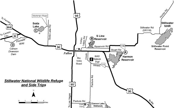 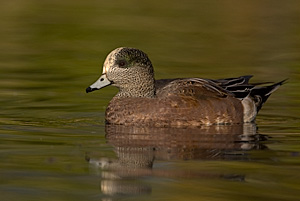 American Wigeon - Photo by Steve Ting American Wigeon - Photo by Steve Ting WHAT TO EXPECT: This urban lake is best known for its waterfowl and gulls, especially during fall and winter. A paved 1-mile walking and jogging path around the lake provides an excellent opportunity to scan and study the large flocks. Patient birders are often rewarded with an unusual gull or duck. More than 110 species have been recorded here.
BEST TIME OF YEAR: November through March, but birding the trees around the park during the spring can be quite productive. NOTABLE SPECIES: Hooded and Common Mergansers, Snow and Ross's Geese, and occasional Barrow's Goldeneye and Eurasian Wigeon may be seen among the sizable flocks of wintering waterfowl, which include Redhead, Ruddy Duck, Northern Shoveler, American Wigeon, Gadwall, and Canada Goose. A surprising number of raptors frequent the lake. Glaucous-winged, Glaucous, Thayer's, Mew or Glaucous-winged x Western hybrid gull individuals can sometimes be found within the large flocks of California and Ring-billed Gulls, particularly in the winter. Also look for small numbers of wintering Herring Gull. Black-crowned Night-Heron have roosted in the large trees at the northeast end of the lake. HOW TO GET THERE: From the I-80 & US 395 interchange, drive approximately 1.5 miles south on US 395 to Exit 65A Plumb Lane. Turn right on East Plumb Lane and proceed 1.5 miles west to Lakeside Drive. Turn left (south) on Lakeside Drive, drive two short blocks, and bear left to the small parking lot at the north end of the lake. POPULAR BIRDING ROUTE: Follow the paved one-mile path around the lake. Note the small island in the south end of the lake, which has provided nesting habitat for a number of species including California Gull, Double-crested Cormorant, and Snowy Egret. 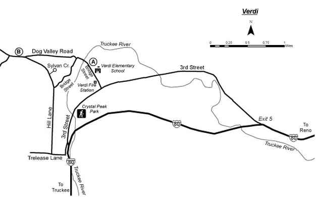 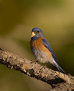 Western Blue Bird - Photo by Steve Ting Western Blue Bird - Photo by Steve Ting WHAT TO EXPECT: Located in the foothills of the Sierra Nevada west of Reno, the town of Verdi (VUR-dye) is surrounded by a variety of habitats including riparian, meadow, aspen, pine forest, and upland shrub. Although considerable development has occurred here, Verdi still offers plenty of opportunities to view and enjoy wildlife.
BEST TIME OF YEAR: April through October NOTABLE SPECIES: Spotted Towhee, Mountain Chickadee, Steller's Jay, woodpeckers, and sapsuckers are readily seen. Golden-crowned Sparrow may occur in winter. Watch for Mountain and Western Bluebirds in open, brushy areas and for migrating songbirds in riparian areas. American Dipper is possible along the Truckee River. HOW TO GET THERE: From the I-80 & US 395 interchange, travel approximately 10 miles west on I-80 to Exit 5 East Verdi. Follow the road to Verdi. From I-80 Exit 5 East Verdi, travel 2.5 miles on 3rd Street (unsigned) to Bridge Street. POPULAR BIRDING ROUTE: Turn right (north) on Bridge Street. Check the trees around the fire station on the left for woodpeckers and migrating songbirds. The entrance and parking for Verdi Nature Trail is at 0.2 mile on the right just past Verdi Elementary School. (Side Trip A) Proceed 0.2 mile past the school to the first bridge. Parking is available only on the right shoulder. The Truckee River can be accessed by a rough trail beginning on the right near a rock bearing a plaque commemorating Crystal Peak Toll Bridge. The trail follows the south bank of the Truckee River along the northern edge of a golf course. Birding is also good on the bridge and on foot for the next 0.7 mile along Bridge Street. From the bridge, drive the short distance to Dog Valley Road and turn right (northwest). Check the old cemetery on the right on Dog Valley Road at 0.2 mile after the turn. At 0.7 mile (Side Trip B) turn left onto the dirt road heading southeast, an extension of Hill Lane (unsigned). Bird along this road for 0.6 mile to the intersection with Sylvan Circle. Bear right (south) and continue 1.0 mile to the end of Hill Lane, watching for Mountain Bluebird on the right. Turn left onto Trelease Road for 0.1 mile to the main road, 3rd Street. Turn left (north) onto 3rd Street and proceed 0.5 mile to the Truckee River. Cross the river and turn right into the entrance to Crystal Peak Park (restrooms). After leaving Crystal Peak Park, turn right (northeast) on 3rd Street and continue to retrace your route 2.8 miles to I-80 to return to Reno. OPTIONAL SIDE TRIPS: Side Trip A Verdi Nature Trail: This 0.5-mile loop trail provides good birding. The trail begins in upland shrub, goes through pine forest edge, then into open meadow, and back to upland shrub. Side Trip B Toiyabe National Forest: Continue on Dog Valley Road into the Toiyabe National Forest. The pavement ends at 1.0 mile from the intersection of Bridge Street and Dog Valley Road and becomes Sierra County Route 860. This dirt road continues approximately 7 miles to Stampede Reservoir. 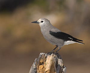 Clark's Nutcracker - Photo by Steve Ting Clark's Nutcracker - Photo by Steve Ting WHAT TO EXPECT: Tahoe Meadows is a lush alpine meadow with adjacent montane forest and riparian habitats. At approximately 8,700 feet, this meadow and surrounding areas support a variety of high-elevation bird species. There are two good birding route options: an easy one-hour interpretive trail around the perimeter of the meadow or a three-hour loop which begins in a lodgepole pine forest and follows Ophir Creek along the south side of the Tahoe Meadows.
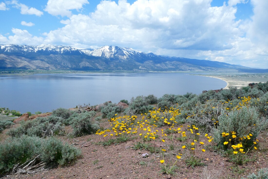
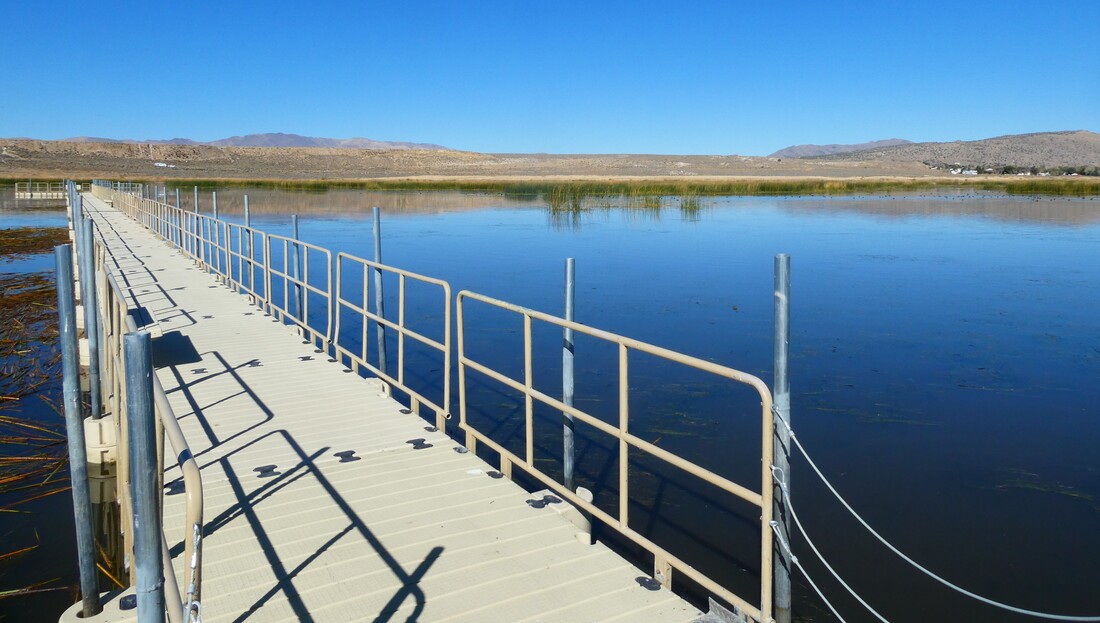
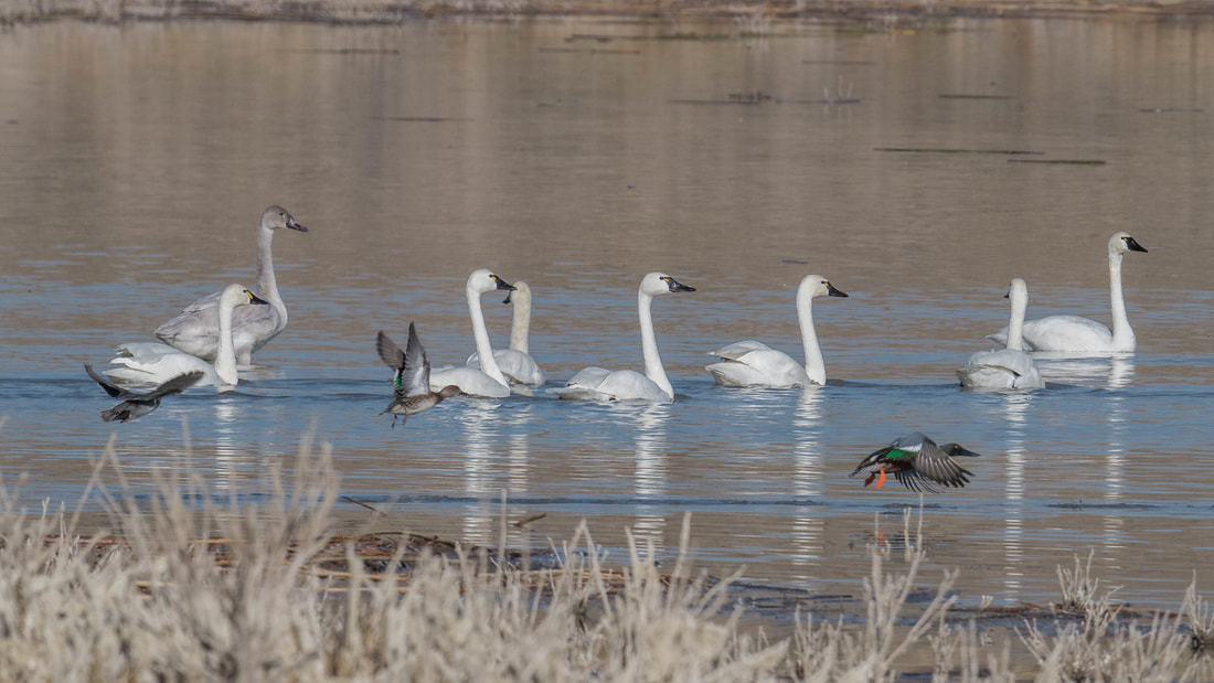
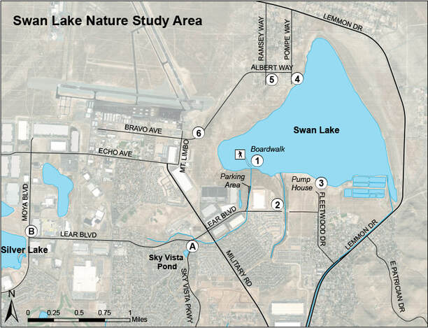
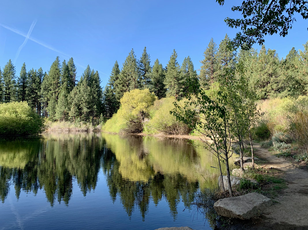
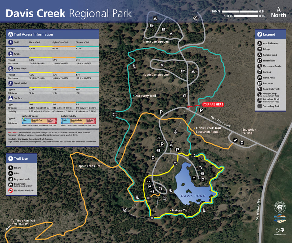
BEST TIME OF YEAR: May through September NOTABLE SPECIES: Hermit Warbler can be seen in the pines at the beginning of the longer Ophir Creek Trail loop. Scan the tree tops for Pine Grosbeak and irruptive species such as Red Crossbill and Evening Grosbeak. Aspen groves occur along Ophir Creek in the lowest portion of the route and attract riparian species such as Wilson's and Yellow Warblers. American Dipper can also be observed along Ophir Creek. Mountain Bluebird is possible. PRECAUTIONS: Be aware of the potential effects of high elevation. A hat and sunscreen are recommended. Mosquito repellant is necessary in spring and summer. Snow may remain along portions of the trails until June. Alpine meadow vegetation is extremely fragile, so do not stray from designated trails. HOW TO GET THERE: From the I-80 & US 395 interchange, drive south approximately 11 miles on US 395 to Exit 56 Mount Rose Highway/SR 431. Bear right onto Mount Rose Highway/SR 431 and proceed another 15.6 miles to the Mount Rose Summit. At 0.6 mile beyond the summit, turn left (southeast) into the parking area (restrooms) for the 1.3 mile Tahoe Meadows Interpretive Trail. To access the 3.0-mile Ophir Creek Trail loop, continue about another 0.7 mile to a wide paved shoulder near a wide, right-bearing road. The trailhead is on the other side (left, southeast) of the highway, where pullout parking is also permitted. Exercise caution when crossing the highway on foot or making a U-turn. Note that this trailhead can also be accessed on foot from the Tahoe Meadows parking and restroom area. A path begins at the the edge of the lower parking lot and initially follows the highway southwest downhill. This path will add nearly 2 miles to the 3.0-mile Ophir Creek Trail loop. POPULAR BIRDING ROUTE: Tahoe Meadows Interpretive Trail: At the parking-restroom area, check the kiosks and brochures. This is also the main trailhead for the Tahoe Rim Trail, and parking may be crowded on weekends and holidays. The 1.3-mile trail (handicapped access) encircles the meadow and soon leaves any highway sounds behind. The trail is level and well-marked. It winds among huge granite boulders and tall pines and along mountain creeks. Ophir Creek Trail loop: From the parking areas along the highway, continue past the beginning of the Tahoe Rim Trail at about 0.3 mile and follow the Ophir Creek Trail. The trail travels gradually downhill through pine forest. Look for Clark's Nutcracker, Cassin's Finch, and the usual montane species such as Red-breasted, White-breasted, and Pygmy Nuthatches, and Mountain Chickadee. As the trail nears Ophir Creek at 1.5 miles, stands of aspen blanket the slopes and willow thickets hug the creek banks. Check for riparian species such as MacGillivray's, Wilson's, and Yellow Warblers, Song Sparrow, and Hermit Thrush. Along this stretch the trail also provides superb views of Washoe Valley and Washoe Lake some 4,000 feet below. (Side Trip A) To return to the trailhead, take the trail to the left heading back uphill, mostly along the creek. Upon reaching the meadow, watch for White-crowned and other sparrow species and Mountain Bluebird. Just before reaching the highway, cross the creek and return to the trailhead. (Side Trip B) OPTIONAL SIDE TRIPS: Side Trip A Ophir Creek Trail: This alpine trail continues downhill from the birding route for a six-mile descent of 4,000 feet to Davis Creek Regional Park in Washoe Valley. A shorter walk down the trail may be worthwhile. The entire trail is very strenuous and requires vehicle shuttling for a one-way hike. Price Lake is at 2.0 miles and a 1,400-foot descent from the birding route. The lower end of the trail may be birded from Davis Creek Regional Park. See Area #20 Washoe Valley Side Trip A. Side Trip B Connection to Area #14 Spooner Lake: Continue southwest on Mount Rose Highway/SR 431 6.6 miles to its intersection with SR 28. Turn left (south) on SR 28 and drive approximately 12.6 miles along the eastern shore of Lake Tahoe to the entrance to Spooner Lake wildlife viewing area on the left (east) side of the highway. 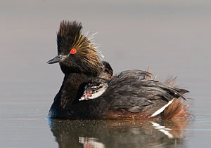 Eared Grebe - Photo by Steve Ting Eared Grebe - Photo by Steve Ting WHAT TO EXPECT: Dedicated in April 1999, Swan Lake Nature Study Area (NSA) is a nearly unspoiled wetland in the midst of suburban housing and warehouses. Depending on annual precipitation, the wetland varies from 100 acres to 1,000 acres. Surrounded by sagebrush, greasewood, and other desert vegetation, this large, shallow lake has a marshy habitat on the west side and adjacent sewage treatment ponds on the east. Over 150 species have been recorded here. Burrowing Owls often nest in man-made boxes located at the west and north edges of the nature study area. Swan Lake NSA is a Nevada Important Bird Area. BEST TINME OF YEAR: Year-round NOTABLE SPECIES: Burrowing Owl is present through the breeding season; Tundra Swan, Greater White-fronted Goose, and ducks are common in winter. American Avocet, Black-necked Stilt, and other shorebirds visit in spring. Check the marshes for Virginia Rail and Sora. Scan the upland areas for sage species. PRECAUTIONS: Stay off the alkali mud flats and any muddy roads to avoid becoming mired. HOW TO GET THERE: From the I-80 & US 395 interchange, travel approximately 6 miles north on US 395 to Exit 74 Lemmon Drive. Turn right (north) onto Lemmon Drive and, depending on the route chosen, follow the directions below. POPULAR BIRDING ROUTES: Marsh Boardwalk: At the southwest side of the marsh, a floating boardwalk with benches and interpretive signs allows visitors to penetrate the marsh and part of the lake for approximately 300 yards. From Exit 74, follow Lemmon Drive 0.8 mile north to Military Road. Turn left (northwest) and follow Military Road 1.5 miles to Lear Boulevard. (Side Trip A) Turn right (east) onto Lear Boulevard and drive 0.4 mile to its end at a gravel road. Turn left and drive 0.2 mile to the Swan Lake NSA parking lot. Walk to the boardwalk. Trails from the interpretive area preceding the boardwalk also provide birding access around the entire southwestern shore. After birding the boardwalk area, the water treatment ponds may be reached by returning to Lemmon Drive via Military Road and following the directions below to Patrician Drive (1.6 miles to the left from Military Road). To return to Reno, turn right (southwest) at Lemmon Drive to reach US 395 south. Lemmon Valley Sewage Treatment Facility ponds: From Exit 74 Lemmon Drive, turn right (north) onto Lemmon Drive. Drive 2.4 miles to Patrician Drive (a well-marked school zone, 1.6 miles beyond Military Road). Turn left on Patrician Drive and make an immediate right turn onto a dirt road, which parallels Lemmon Drive. Proceed 0.4 mile to the Lemmon Valley Sewage Treatment Facility. At the plant bear to the right and follow the 0.3-mile fence line to bird the ponds on the left. At the north end of the fence line, park and walk the fence line or dike. Swan Lake is visible to the north. Walk or drive the 0.3-mile dirt road along the north side of the pond. A good vehicle turnaround is 0.1 mile to the left of the northwest corner of the pond. Return to the treatment facility and to Patrician Drive. ADDITIONAL BIRDING AREAS: Swan Lake may be viewed from several vantage points, described here in a counterclockwise sequence from southeast to southwest. Distances are in short increments through residential areas.
Side Trip A Sky Vista Pond: From the intersection of Military Road and Lear Boulevard, travel west on Lear into the entrance to Sky Vista Estates and turn at Sky Vista Parkway, the first left (south). At 0.1 mile stop beside a small pond on the right side of the street. A paved walk circles the pond which, although used by local residents and dogs, is worth a short visit.  Boardwalk at Lemmon Valley Marsh - Photo by Steve Ting 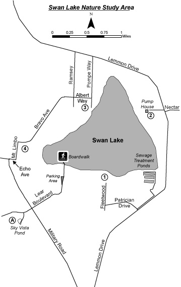 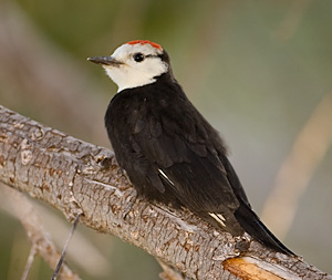 White Headed Woodpecker - Photo by Steve Ting White Headed Woodpecker - Photo by Steve Ting WHAT TO EXPECT: Spooner Lake, an alpine lake at 7,100 feet elevation, lies within 12,242-acre Lake Tahoe Nevada State Park. The 2-mile Spooner Lake Loop Trail is a well-maintained interpretive trail through meadows, pine and fir forest, and aspen groves. There are developed picnic sites spread throughout Jeffrey pines and white firs on the bluff above the lake. Spooner Lake is also a major trailhead for hikers, mountain bikers, and equestrians entering the back country. The picnic areas and a loop trail provide an easy, accessible mountain birding experience. Spooner Lake is part of the Carson Range Nevada Important Bird Area.
BEST TIME OF YEAR: May through July NOTABLE SPECIES: Osprey fish the lake. Three species of nuthatches, Steller's Jay, Clark's Nutcracker, Brown Creeper, and Mountain Chickadee are resident as are Red-breasted and Williamson's Sapsuckers and Downy, Hairy, and White-headed Woodpeckers. Spring migration brings Common Loon, Spotted Sandpiper, Western Wood-Pewee, Tree and Barn Swallows, Hermit Thrush, Western Tanager, Warbling and occasionally Cassin's Vireos, and a variety of warblers. Sooty Grouse, Northern Pygmy-Owl, and Black-backed Woodpecker are among the more elusive species here. PRECAUTIONS: This is a popular cross-country ski area during the winter. Also take note of posted cautions about bears. HOW TO GET THERE: From the I-80 & US 395 interchange, take US 395 south approximately 27 miles to Carson City, Exit 43 North Carson Street/US 395 Business. Travel 6 additional miles south through Carson City to the US 50 west/Lake Tahoe junction. Turn right (west) on US 50 and travel approximately 9.8 miles to the US 50 & SR 28 intersection. Turn right (north) onto SR 28 and look for the Spooner Lake entrance on the right at approximately 0.6 mile. Day use fee. POPULAR BIRDING ROUTE: Park near the restroom structure (handicapped access). A kiosk in front of the structure displays a map of the Spooner Lake Loop Trail. From this area, follow signs indicating "To All Trails" in a northeasterly direction. Shortly, at the end of the paved paths, a sign indicates, "Marlette Lake Flume Trail." Follow the broad path downhill beyond the sign about 400 yards to its dead end. To the left is a sign "North Canyon Trail," which begins a 5-mile one-way hike to Marlette Lake. Continue instead to the right, down another 50 yards to the west side of Spooner Lake. The favored route is to go to the left and circle the lake in a clockwise fashion. In this direction, the first part of the walk is principally in the sun with the latter part passing through more wooded areas. Toward the end of the loop, a sign somewhat south of where the loop began will direct you uphill to return to the picnic and parking area. On leaving Spooner Lake, turn left and backtrack to US 50 for Side Trip A, or turn right to return to Reno via Incline Village (Side Trip B). OPTIONAL SIDE TRIPS: Side Trip A Spooner Summit: Just east of the Spooner summit on the south side of US 50, at about 0.8 mile east of SR 28, is a U.S. Forest Service rest stop (restrooms) and picnic area. There is good birding along a small creek which runs through an extensive aspen grove. You can walk along the dirt road on the far side of the creek. The rest stop is an access point to the Tahoe Rim Trail north- and southbound. Side Trip B Connection to Area #17 Tahoe Meadows and Area #6 Galena Creek Regional Park: When you leave Spooner Lake, turning right (north) on SR 28 offers a return trip to Reno along approximately 11 miles of the eastern shore of Lake Tahoe. At the first stoplight in Incline Village turn right (northeast) onto Country Club Drive, a 2.3 mile cutoff to SR 431/Mount Rose Highway. At the stop sign at SR 431/Mount Rose Highway, turn right (east) to return to US 395 in Reno (22 miles). From this turn, SR 431/Mount Rose Highway passes a notable scenic overlook of Lake Tahoe at 1.3 miles on the right, Area #17 Tahoe Meadows on the right at 4.3 miles, and Area #6 Galena Creek on the left at about 15 miles. Note: SR 431/Mount Rose Highway, which descends from a 9,000-foot summit, is a well-maintained, two-lane mountain highway at times steep and sharply curved. In winter it is subject to very heavy snowfalls and heavy traffic to and from popular ski resorts. 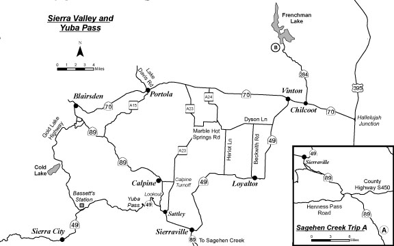  Rough-legged Hawk - Photo by Alan Gubanich Rough-legged Hawk - Photo by Alan Gubanich WHAT TO EXPECT: Sierra Valley is a broad, open valley in Northern California with a mix of seasonally flooded sagebrush flats, agricultural fields, and wetlands formed by the headwaters of the Feather River. This area is excellent for wintering waterfowl and raptors, as well as spring migrants and marsh birds. Sandhill Cranes usually nest in the valley. At the western edge of the valley, Yuba Pass (elevation 6,701 feet) offers prime mountain forest habitat. At the right time of year, it is possible to see over 100 species in a day by starting at Yuba Pass in early morning, continuing through the valley, and ending at Frenchman Lake to the east.
BEST TIME OF YEAR: Sierra Valley itself can be productive at any time of year. Mid-October through February is the best time for raptors, while May through June offers the most diversity. Yuba Pass is best from May through June. NOTABLE SPECIES: Sandhill Crane, Hermit Warbler, Black-backed Woodpecker, sapsuckers, Calliope Hummingbird, Sooty Grouse, Northern Pygmy-Owl, Mountain Quail, eagles, hawks, and geese may be found in appropriate habitats. (See the Popular Birding Routes.) PRECAUTIONS: Exercise caution on dirt roads in central Sierra Valley, particularly after heavy rains. HOW TO GET THERE: From the I-80 & US 395 interchange, drive north on US 395 for approximately 24 miles to Hallelujah Junction/SR 70. Exit and turn left (west) onto SR 70. Drive 7.9 miles to Vinton. POPULAR BIRDING ROUTE: Springtime Route: From Vinton, continue west an additional 12 miles to A23 and turn left (south). Continue another 11.8 miles on A23 to the Calpine turnoff to SR 89. Turn right (west) on the cutoff and drive 1.3 miles to SR 89. The stand of pine trees on the south side of the road can be a good place to find owls. Turn left on SR 89 (southeast) and continue 3 miles to SR 49. Turn right (west) on SR 49 to Yuba Pass and Downieville. The willows and small meadows at about 1.1 mile often have numerous warblers and hummingbirds, including Calliope. The lookout at 2 miles is a good place to listen for Winter Wren and Northern Pygmy-Owl. Proceed 4 miles from the lookout to Yuba Pass. Park in the lot on the south side of the road. The first quarter- to half-mile of the roads to the north and south of the parking lot as well as the small adjacent meadow can be productive. These areas, birded in early morning, are the best spots to find Black-backed Woodpecker and Williamson's Sapsucker, as well as Hermit and Townsend's Warblers. Mountain Quail can also be found here. If time permits, continue west from Yuba Pass on SR 49 for 7 miles to Bassett's Station on the right side of the highway (food, gas, restrooms). Check the hummingbird feeders at the restaurant, then walk to the bridge over the North Yuba River on the south side of SR 49 to look for American Dipper. Retrace your route on SR 49 back to the junction of SR 49 & SR 89. At the SR 49 & SR 89 junction continue straight ahead 0.9 miles on SR 49/SR 89 to Sattley. (Side Trip A) At Sattley turn left (north) onto Route A23 and drive about 10.7 miles to unsigned Marble Hot Spring Road, a dirt road (look for a small power station just north of the road). Turn right (east). For the next 3.3 miles, until Marble Hot Spring Road joins A24, stop frequently to check for Brewer's and Vesper Sparrows as well as Sandhill Cranes, bitterns, and terns. The old iron bridge is a great place to view up to six species of swallows. Where Marble Hot Spring Road joins A24 (unsigned) at a stop sign, turn left (north) and drive 4.4 miles to SR 70. Route A24 is rather narrow, but birding can be productive. The seasonally flooded sagebrush habitat along this road may produce Short-eared Owl. Turn right (east) onto SR 70 to return to Reno. (Side Trip B) Fall/Winter Route: From Vinton, turn left (south to Loyalton) on SR 49 and drive 3.6 miles to Dyson Lane. Turn right (west) on Dyson Lane. This is great raptor country. Continue 5.3 miles to Heriot Lane (misspelled "Harriet Lane" on the sign) and turn left (south). Drive 5 miles to SR 49, which follows the eastern and southern boundaries of Sierra Valley. The fields on both sides of the road just before arriving at SR 49 tend to be the best places to find Ferruginous Hawk. Turn right (west) on SR 49 and drive 9.4 miles to Sierraville. Continue right (west) on SR 49/SR 89 for 4.4 miles to Sattley and turn right (north) on A23. Drive about 10.7 miles to unsigned Marble Hot Spring Road, a dirt road (look for a small power station just north of the road). Turn right (east) and drive 3.3 miles until Marble Hot Spring Road joins A24 (unsigned) at a stop sign. Turn right (southeast) at this junction and continue east (now Dyson Lane) until it dead-ends at SR 49. Turn left (north) to return to Vinton and then back to Reno. OPTIONAL SIDE TRIPS: Side Trip A Sagehen Creek: This is one of the finest riparian areas in the region. From Sattley, continue another 3.9 miles east on SR 49/SR 89 to the junction where SR 89 turns south in Sierraville. Turn right (south) on SR 89 and drive 16.2 miles to Sagehen Creek (unsigned). Park in the dirt parking area on the left just before the bridge over Sagehen Creek. Two routes are possible. To follow Sagehen Creek east 2 miles to Stampede Reservoir, take the trail from the parking area along the north side of the creek. To follow Sagehen Creek west, cross the highway and make your way through boggy seep areas along the south side of the Creek, finally reaching meadows and higher ground. The latter option is better late in the summer. From the parking area, return to Reno either by turning left (south) 7.5 miles on SR 89 to Truckee and from there 30 miles back to Reno on I-80 east or by turning right (north) and retracing your route through Sierraville and Hallelujah Junction. Side Trip B Frenchman Lake: This reservoir lies at the head of a high-walled, narrow canyon in an area of ponderosa pine and mountain mahogany. From Vinton drive 2 miles east on SR 70 to Chilcoot, which is approximately 30 miles from Reno. Turn left (north) onto Frenchman Lake Road/SR 284 and drive 8.4 miles to the reservoir. En route, bird the canyon's rich riparian areas, checking for American Dipper, Violet-green Swallow, warblers, vireos, orioles, and other songbirds. When you reach the reservoir, circled by a good road, park at the dam and look for loons and diving ducks. If time permits, circle the lake, birding along the way; or return to SR 70. 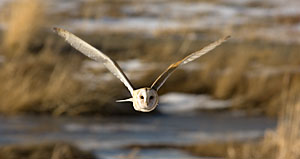 Barn Owl - Photo by Steve Ting Barn Owl - Photo by Steve Ting WHAT TO EXPECT: Peavine Peak, northwest of Reno, offers a variety of habitats. The main road passes through predominately sagebrush-covered hillsides, stands of mountain mahogany, and areas of manzanita and assorted low-growing sub-alpine vegetation. An optional side trip provides opportunities to bird riparian habitat. This mountain offers breathtaking views of the entire Truckee Meadows and northern valleys.
BEST TIME OF YEAR: May through September NOTABLE SPECIES: Check the northern and eastern slopes for Great Horned, Barn, Northern Saw-whet, Long-eared, Western Screech- and Northern Pygmy-Owl. Common Poorwill sometimes return as early as the first part of April. Lazuli Bunting and Blue-gray Gnatcatcher are regular in appropriate habitats. Aspen groves on the southern slopes are good sites for Empidonax flycatchers and Broad-tailed Hummingbird. PRECAUTIONS: Peavine Peak is notorious for high winds, especially at the top. At an elevation of 8,300 feet, the mountain is much higher than it appears, and inclement weather should not be discounted at any time of year. HOW TO GET THERE: From the I-80 & US 395 interchange, drive north on US 395 for approximately 8 miles to Exit 76 Stead Boulevard. Exit and turn left on Stead Boulevard. Drive 0.3 mile to North Virginia Street and turn right. Continue on North Virginia Street for 0.6 mile and turn left onto a wide dirt road (unsigned) after the railroad tracks. Although a high-clearance vehicle is recommended, most standard passenger cars can also make it. The road improves after the first two miles. POPULAR BIRDING ROUTE: From the North Virginia Street/unsigned access road junction, drive 6.7 miles to the top of the mountain. As you travel up the mountain, stop frequently to bird a variety of habitats. Many side roads branch off of the main road. (Side Trip A) Caution should be taken when exploring any of these side roads, which require high-clearance vehicles. There are many areas along the main route that can be birded on foot. Park sufficiently to the side to allow other vehicles to pass. Backtrack to North Virginia Street; turn right (south), proceeding to a left turn onto Stead Boulevard to return to US 395 and Reno. OPTIONAL SIDE TRIPS: Side Trip A Common Poorwill road (near sunset): Due to heavy washouts this 1-mile road is only accessible on foot. From the North Virginia Street/unsigned access road junction, drive either 0.5 mile to the south end of the road (on the left) or 1.5 miles to the north end of the road, which cuts back sharply to the left and parallels the main road. The willows along the creek offer good riparian birding, but the area is best known for Common Poorwill, especially at sunset. 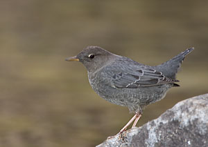 American Dipper - Photo by Steve Ting American Dipper - Photo by Steve Ting WHAT TO EXPECT: Oxbow Nature Study Area is one of the few relatively intact riparian areas along the Truckee River in Reno. It is characterized by mature cottonwoods, Russian olive trees, willows, dense brush piles, and a small pond with thick cattails. A wheelchair-accessible boardwalk begins near the Interpretive Center. This is an excellent place to spend just a few minutes or a few hours.
BEST TIME OF YEAR: Year-round. During fall and early winter this is an excellent migrant trap, with spring also good for migrants and vagrants. NOTABLE SPECIES: American Dipper is possible along the river. Check the willow tops for Anna's Hummingbird, a regular migrant; a few have oversummered. Green Heron and Sora are possible at the pond. White-throated Sparrow, Winter Wren, Red-shouldered Hawk, and Varied Thrush have been found in the area. Check for vagrants among the large flocks of wintering sparrows. Bohemian Waxwings may be found in the large Cedar Waxwing flocks. PRECAUTIONS: Oxbow Nature Study Area is heavily used by the general public and the local school district for field trips and teacher workshops. HOW TO GET THERE: From the I-80 & I-580 interchange, drive west on I-80 approximately 2 miles to Exit 12 Keystone Avenue. Turn left (south) on Keystone Avenue and proceed 0.5 mile to West Second Street. Turn right (west) on West Second Street, which turns into Dickerson Road, and follow this for about 1 mile. Dickerson Road terminates at the Oxbow Nature Study Area parking lot and Interpretive Center. POPULAR BIRDING ROUTE: Walk to the left of the parking lot to the viewing platform at the edge of the river. Return to bird the cattail pond west of the Interpretive Center. An upper viewing platform affords an overview of the pond and surrounding area. A lower deck brings you pondside. After birding these two areas, follow the boardwalk and path along the Truckee River for approximately 0.5 mile. Return to the Interpretive Center. 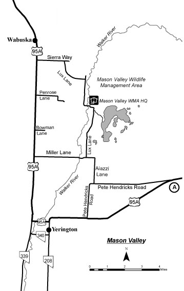 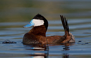 Ruddy Duck - Photo by Steve Ting Ruddy Duck - Photo by Steve Ting WHAT TO EXPECT: Mason Valley Wildlife Management Area (WMA) is a large wetlands area surrounded by agricultural fields about 11 miles northeast of Yerington. The area is managed for waterfowl and has numerous dikes and extensive areas of buffaloberry.
BEST TIME OF YEAR: October through May NOTABLE SPECIES: Black, Caspian, and Forster's Terns as well as Osprey are present in spring and summer. This is one of the best spots in northern Nevada to see Great-tailed Grackle, Black Phoebe, Blue Grosbeak (usually in the buffaloberry), Ash-throated Flycatcher, Wild Turkey, and a variety of raptors. During migration the area is good for waterfowl and shorebirds; large numbers of waterfowl winter here. PRECAUTIONS: Check with the WMA Headquarters (775-463-2741) for hunting season dates in fall, winter, and spring. In wet weather the area gets muddy; stay on the roads. HOW TO GET THERE: From the I-80 & US 395 interchange, take I-80 east approximately 31 miles to Exit 46 West Fernley. Drive into town; turn right (south) on Alternate US 95 to Hawthorne/Yerington. Follow Alternate US 95 through Silver Springs to Wabuska, approximately 34 miles south of Fernley. Continue another 1.1 miles to Sierra Way. Sierra Way, however, may be closed October 1 through January 1 for hunting. If so, continue another 5.4 miles south to Miller Lane, drive east 3 miles, turn left (north) into the WMA, and reverse the directions given in the Popular Birding Route. POPULAR BIRDING ROUTE: If you use Sierra Way, drive 1.5 miles to Lux Lane (dirt) and turn right. There is a good marshy area on the left side of the road at 1.6 miles. Turn left at that point and proceed to the Fort Churchill Pond parking area. Bird the area, then continue a short walk up to the top of the nearby dike, a good spot for accessing the south end of the cooling ponds associated with the Fort Churchill Power Station. Return to Lux Lane and continue south 2.2 miles past the WMA Headquarters to the road entering the pond areas, birding the buffaloberry along the side of the road. The extensive pond areas may be birded by vehicle or on foot. Continue 2.8 miles on Lux Lane to Miller Lane. Turn right (west) on Miller Lane to return to Alternate US 95, or turn left (east) to bird the surrounding agricultural fields. To the east, Miller Lane turns south and becomes Aiazzi Lane, which ends in 2.0 miles at Pete Hendricks Road. Turn right and continue birding another 2.3 miles, to where Pete Hendricks Road connects with Alternate US 95. (Side Trip A) Turn right (west) to drive into Yerington. To return to Reno, continue north on Alternate US 95 back to I-80 west in Fernley. OPTIONAL SIDE TRIPS: Side Trip A Walker Lake: From the intersection of Pete Hendricks Road and Alternate US 95, take Alternate US 95 left (east) 25 miles to Schurz, then continue 19 miles south on US 95 to the lake. From Sportsman's Beach just off of US 95 scope for waterfowl that eat plants and invertebrates like American Coot, Ruddy Duck, Northern Shoveler, Eared Grebe, Wester/Clark's Grebe, Lesser Scaup, Green-winged Teal.
|